Region
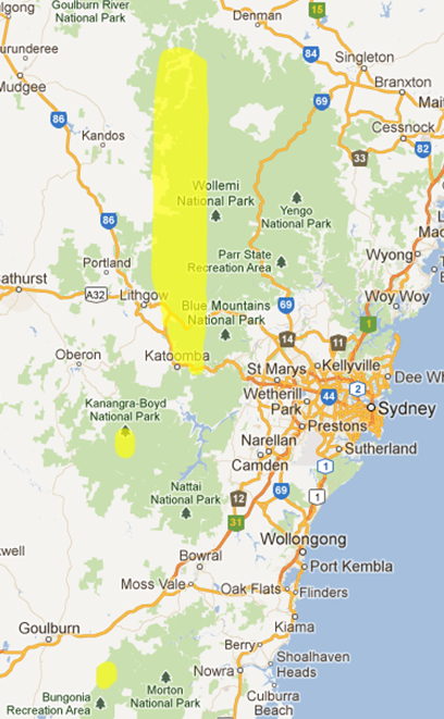
The sandstone slot canyons near Sydney are all found in the Greater Blue Mountains area. They lie in the northern half of the Blue Mountains National Park, in Wollemi NP, with some in the Gardens of Stone NP and in nearby State Forest or Crown Land. They can be found in a narrow band running north-south, on the western side of the ranges.
To the south are the more open canyons of Kanangra, and further south again is the Bungonia area.
The three areas can be seen in yellow in the map at right.
Below is a brief overview of the canyons to be found in the more popular canyoning areas. For more information on the towns near to the canyoning area, see the Nearby Towns page
Newnes
The Wolgan River has many canyon tributaries, located on the tops to the north of Newnes and on Island Mountain to the south of Newnes. There are also canyon tributaries further downstream below Rocky Creek. The most commonly visited ones are close to Newnes itself. Devils Pinch Canyon, Newnes (Starlight) Canyon and Pipeline Canyon are all excellent canyons, and are fairly easily accessible. Firefly Canyon and Looking Glass Canyon are also nearby on Island Mountain.
Maps (1:25,000): Mount Morgan, Ben Bullen
Access: From Sydney, follow the Great Western Highway to Lithgow. Stay on the Highway past Lithgow and take the Mudgee turnoff on the left about 8km past the traffic lights at Lithgow. 4km further on at Wallerawang, take the signposted turnoff to the right to Newnes. About 500m further on, keep going straight ahead (where the road veers left) in the town of Lidsdale. It is about 10km to the top of Wolgan Gap, where the road becomes narrow and winding for about 2km down the steep descent. Then it is another 14km of bitumen road to the Wolgan Valley Resort, and a ford at Barton Creek. From there it is dirt road for the last 8.5km to Newnes, usually fairly good quality.
Camping: There is a kiosk/information centre in the old hotel on the left, and the main campsite is 1km further on. Newnes (Little Capertee) campground has pit toilets (BYO loo paper just in case) and a lovely big grassy area, with lots of options for camping. You'll often see wombats and wallabies at dusk.
Services: The only services at Newnes are a small kiosk which has no refrigeration and is only open on the weekends. The nearest food and petrol is the service station in Lidsdale. Nearest supermarket and other services is Lithgow.
Driving times:
- from Sydney: 3h
- from Lithgow: 1h
South Wolgan
The South Wolgan area covers the tributaries of Rocky Creek, Deanes Creek and Annie Rowan Creek, and a few smaller tributaries of the Wolgan River. The most popular canyons are probably Twister Canyon and Rocky Creek Canyon, as they can be done without abseiling, and Tiger Snake Canyon, which can be visited all year round. Rocky Creek in particular is spectacular, with a long dark constriction that is almost as long as that of Claustral Canyon. Other good canyons in the area include Surefire Canyon and Galah Canyon.
Maps (1:25,000): Rock Hill, Mount Morgan, Ben Bullen, Cullen Bullen (driving)
Access: The whole area is a mess of fire trails, so driving instructions can be found at Newnes Plateau & South Wolgan Fire Trails. The fire trails are usually 2wd accessible, but some may require high clearance.
Camping: The Barcoo Swamp camping area lies off Galah Mountain Rd, just after it leaves the Glowworm Tunnel Rd. This is a nice grassy area, and most of the canyons are less than 20 minutes drive from here. This is a primitive camping area, with no facilities, so please toilet responsibly.
Deep Pass camping area is also lovely, but requires a 15 minute walk from the car.
Services: Nearest food and petrol is in Lithgow, which has full services and supermarkets.
Driving times (to Barcoo Swamp)
- from Sydney: 2h 45m
- from Lithgow: 45m
Bungleboori
Many of the tributaries of the north branch (Dingo Creek) and the south branch of Bungleboori Creek have sections of canyon in them. The best ones include Crikey Canyon, Luna Park Canyon, Banks Canyon and Hole-in-the-Wall Canyon. Dingo Creek also has an impressive canyon section downstream from the Hole-in-the-Wall junction. The north-south running canyons are typically drier than those to the south and east, with short wades and the occasional swim.
Maps (1:25,000): Wollangambe, Rock Hill, Lithgow (driving), Cullen Bullen (driving)
Access: Access is similar to the South Wolgan area. Driving instructions can be found at Newnes Plateau & South Wolgan Fire Trails. Fire trails are 2wd accessible under normal conditions.
Camping: There is a small amount of primitive camping at the end of the road at Waratah Ridge. Please keep the area clean.
Services: The nearest food and petrol is in Lithgow, which has full services and supermarkets.
Driving times
- from Sydney: 2h 30m
- from Lithgow: 30m
Wollangambe
The Wollangambe River flows north of Mt Wilson, a small hamlet off Bells Line of Road. Major tributaries of the Wollangambe include Bowens Creek, Dumbano Creek and Yarramun Creek. Both the Wollangambe River and the major tributaries flow roughly west to east, and contain long sections of relatively flat canyons, with mostly small waterfalls. Many of the minor tributaries of these creeks are canyons also. The most commonly visited ones are close to Mt Wilson itself. The best of these include Whungee Wheengee Canyon, Upper Bowens Creek South Canyon and Lower Bowens Creek North Canyon. Other popular ones include Geronimo Canyon and Why-Don't-We-Do-It-In-The-Road? Canyon.
Maps (1:25,000): Mount Wilson, Wollangambe
Access: Coming from Sydney, turn right off Bells Line of Road (B59) on to Mt Wilson Rd, about 20km past the Mt Tomah Botanic Gardens.
Camping: Mt Wilson has a great campground at Cathedral Reserve, on the far (north-east) side of town. There are pit toilets (BYO loo paper just in case) and a water tank, though you may want to bring drinking water. Please keep the area clean, and fires in the fire rings.
Services: Mt Wilson has a couple of small cafes, but no services. Nearest petrol is in Lithgow or Mt Victoria. Nearest supermarkets are Lithgow and Katoomba.
Driving times
- from Sydney: 2h
- from Lithgow: 30m
- from Mt Victoria: 30m
- from Katoomba: 45m
North Grose
The North Grose canyons lie on the south side of Bells Line of Road, west of the Explorers Range (Mt Banks). They are mostly lower quality canyons, in small creeks, and as a result are typically fairly dry. Their main attraction is their proximity to Sydney and easy access. Dargans Creek Canyon, though not technically flowing into the Grose, is probably the best quality canyon. Yileen Canyon and Dalpura Canyon are also pleasant outings.
Maps (1:25,000): Mount Wilson
Access: The epicentre of the area is the turn-off to Mt Wilson off Bells Line of Road (B59), which is about 15 minutes drive from Mt Wilson. See the Wollangambe section for information on services, food and camping. Driving times are around 15 minutes less.
Carmarthen Labyrinth
The Carmarthen Labyrinth is one of the most spectacular areas for canyons, boasting the classics of Claustral, Ranon and Thunder Canyons, all joining in Thunder Gorge. They all feature long, deep and dark constrictions, and their proximity to Mt Tomah means they are wetter than most. Claustral is the most popular of the three, though with the new entrance/exit, Ranon should also become more popular as it no longer requires a car shuffle. The lesser known Burumin Canyon (Explorers Brook) and King Georges Brook Canyon also have long canyon sections.
Maps (1:25,000): Mount Wilson
Access: Access is from Bells Line of Road (B59) past Mt Tomah.
Camping: Nearest camping is at Mt Wilson - see Wollangambe section for more info.
Services: Nearest petrol is Lithgow or Mt Victoria (west) or Kurrajong (east), about 25mins either way. Nearest supermarkets are Lithgow (west) or North Richmond (east).
Driving times (to Mt Tomah)
- from Sydney: 1h 30m
- from Mt Wilson: 25m
- from Katoomba: 40m
South Grose
The South Grose region sports a variety of canyons, from the short but spectacular Mt Hay Canyon, to the long, impressive Grand Canyon, as well as pretty creeks but less exciting canyons such as Hat Hill Canyon. Most of the South Grose Canyons are wet, though not all require swimming. The Grand Canyon is the pick of the canyons in the area for quality. Other good canyons include Arethusa Canyon, Hat Hill Canyon, Fortress Canyon and Mt Hay Canyon.
Maps (1:25,000): Mount Wilson, Katoomba
Access: The canyons are accessed via various fire trails that lead off the north side of the main western ridge through the Blue Mountains, near Leura, Katoomba and Blackheath. This is the same ridge that the Great Western Highway (A32), the major east-west road through the mountains runs along.
Camping: There is easy access to food and services, but free camping is limited. Primitive camping is possible off Mt Hay Rd, near the trackheads for Fortress and Mt Hay Canyons, out of Leura. There are a small number of (free) official camping sites at Perrys Lookdown, at the end of Hat Hill Rd at Blackheath. There is also a (free) official camping area on the south side of Blackheath, at Blackheath Glen, on the Megalong Valley Rd.
If you are feeling flush, there is plenty of accommodation in the three towns, from hostels to resorts, and a private campground in Katoomba.
Services: There are large supermarkets in Katoomba and Leura.
Katoomba also has a number of outdoor gear stores (Summit Gear, Paddy Pallin, Mountain Designs), and is the only place you will be able to get technical gear in the upper Blue Mountains.
Driving times (to Katoomba)
- from Sydney: 1h 30m
- from Leura: 5m
- from Blackheath: 15m
Jamison Valley
Empress Canyon is the only well-known canyon on the south side of the main Blue Mountains ridge. Given its quality, it is perhaps surprising that there are no others. There are certainly a few short slots, and some of these can be seen from walks such as the National Pass (Den Fenella for example) and Prince Henry Cliff Walk.
Maps (1:25,000): Katoomba
Access: Empress Canyon is in Wentworth Falls, only a short drive from Katoomba. See the South Grose region for information on camping, food and services.
Driving times (to Wentworth Falls)
- from Sydney: 1h 25m
- from Katoomba: 5m
Kanangra
The Kanangra canyons are quite a different experience from the canyons of the northern Blue Mountains. The rock is typically quartzite and related rocks, rather than sandstone, and the rocks are significantly more slippery as a result. The waterfalls are much bigger, the exposure is greater, and the canyons are more open. In most cases the canyons do not have a true slot, although Kanangra and Danae Brook do have slot sections. Kalang Falls is a good trip, and Dione Dell is a relatively easy canyon, and popular as it doesn't require swimming.
Maps (1:25,000): Kanangra, Yerranderie
Access: Kanangra Walls is a hard 220km drive from Sydney, particularly on a Friday night, as many parties do. Without stops, expect to take 3 to 3 1/2 hours.
Take the Great Western Highway through the Blue Mountains and take the Jenolan Caves Road turnoff to the left at Hartley, which is signposted not far past the big downhill at Mt Victoria. Past Hampton, the road via Jenolan Caves is steep and windy, and not pleasant at all. At the T-intersection on the far side of the caves, take the left turn to Kanangra Walls. The last 30km or so to Kanangra Walls themselves are on dirt road, which varies in quality, but is normally fine for 2wd vehicles.
An alternative route that avoids Jenolan Caves is to take a right turn towards Oberon at Hampton. Turn left on Titania Rd about 5km short of Oberon (signposted) and then follow the signs to Kanangra Walls. This route adds about 12km, but takes a similar time and avoids the narrow winding section through the Jenolan Caves.
Camping: Camping is at the Boyd River Campground, about 6km, back from Kanangra Walls. There are pit toilets, fire rings and a shelter shed.
Services: Nearest food and services are at Oberon.
Driving times
- from Sydney: 3h 10m
- from Katoomba: 1h 40m
- from Oberon: 50m
Bungonia
The canyons around Bungonia are somewhat similar to Kanangra. The main slot canyon in Bungonia Creek is limestone, and can be walked through. However the abseiling canyons are a mix of quartzite and other rocks. The canyons are open, more like gorges, with large waterfalls. Bungonia Creek and Jerrara Creek can be easily accessed from the campground and are popular. Spring Creek used to be a popular trip, but it is closed because of loose rock. Long Gully is open, although NPWS advises against trips there for the same reason.
Maps (1:25,000): Bungonia, Caoura
Access: The main road access to Bungonia State Conservation Area is fairly well signposted from both Goulburn and Marulan. From Sydney, head south west on the Hume Highway and take the exit just south of Marulan, passing straight through the roundabout. At the next T-intersection after 16km turn left to the town of Bungonia, and then left just past the middle of town. The State Conservation Area is about 10km down the road.
Camping: There is a national parks campground at Bungonia, which includes hot showers. Fees apply.
Services: Nearest services are on the Hume Hwy (M31) at Marulan. Nearest supermarket and other shops are at Goulburn.
Driving times
- from Sydney: 2h
- from Goulburn: 25m
- from Marulan: 15m