MGA Grid References
Grid references on this website are in the format of MGA464639. The MGA refers to the Map Grid of Australia, which is the projection used by modern NSW maps. In the example shown (extract from Katoomba map), the grid reference of Spot Height 615, in the top centre of the map, is MGA464639. The East (46) and North (63) kilometre squares can be read off the sides, and the 100m squares are estimated (an exact grid has been overlaid for demonstration purposes).
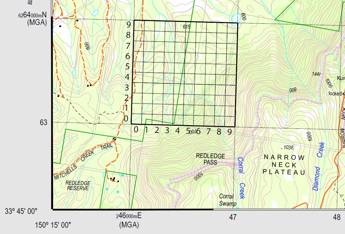
The MGA projection is essentially the same as a UTM (Universal Transverse Mercator) projection of WGS84. If you are using a GPS, set the datum to WGS84, and the position format to UTM/UPS.
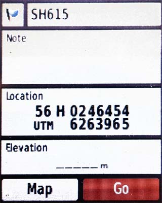
To read the six-figure grid reference off a GPS, take the middle 3 digits of each row of the location - in the GPS screenshot at right, this is 464639.
Converting Grid References
For many people, the information below is now largely redundant. All track notes on the site have been updated with MGA map references. All new NSW maps, as well as the printable maps on this website, use the MGA map grid, and so no conversions are required. If you only have new maps, you can use the MGA references, and WGS84 settings on your GPS.
If, however, you come across or use older maps, then you may need to refer to this information.
Short version
AMG - grid references used on old series NSW 1:25000 maps
MGA - grid references used on new series NSW 1:25000 maps (the ones with the photo on the back)
Skip to the conversion method if you don't want to read the long version
Long version
The map references on the pages in this site are prefixed by either AMG or MGA. These refer to the two coordinate systems on the 1:25000 series maps used by bushwalkers in NSW. These maps are now produced by NSW Spatial Services, formerly the Department of Lands, formerly LPI - Land and Property Information, formerly LIC (Land Information Centre), and before that CMA (Central Mapping Authority), which are names you may probably see printed on your maps.
A coordinate system translates geographic coordinates (eg latitude/longitude) to cartesian coordinates (X/Y or Eastings/Northings). AMG refers to the Australian Map Grid 1966/1984, which was used to produce all of the old series maps. MGA refers to the Map Grid of Australia 1994, which is being used to produce the new series maps (with photo map on the back).
The two different map grids are based on different datums. A datum is the mathematical model of the earth, and the map grid is a projection of this into cartesian coordinates. The Australian Map Grid (AMG) is based on a Universal Transverse Mercator projection of the Australian Geodetic Datum 1966 (AGD66). The Map Grid of Australia (MGA) is based on a Universal Transverse Mercator projection of the Geocentric Datum of Australia 1994 (GDA94). The advantage of using the new datum is that it is almost identical to the WGS84 datum that is used for the GPS (Global Positioning System), and hence is more compatible worldwide.
There is a difference between the two datums which means that co-ordinates based on a projection of one datum need to be converted before they can be used in the other. Luckily, for bushwalking purposes, a reasonably simple conversion will suffice for most purposes.
Converting grid references
If you have a 6-figure grid reference from an old series map but are using a new series map (ie converting AMG to MGA) then
- increase the eastings by 1 and the northings by 2; or equally
- add 1 to the first 3 digits and 2 to the second 3 digits
If you have a 6-figure grid reference from a new series map but are using an old series map (ie converting MGA to AMG) then
- decrease the eastings by 1 and the northings by 2; or equally
- subtract 1 from the first 3 digits and 2 from the second 3 digits
As an example, AMG553874 becomes MGA554876.
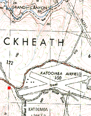
In the map sections below, you can see how the Medlow Bath trig point (highlighted in red) has moved north and east when moving from the 2nd edition (AMG) map to the 3rd edition (MGA) map of Katoomba
All maps of the canyoning areas have been updated to MGA, so all references on the site are now MGA. For maps that were updated more recently, there may also be AMG grid references, in case people are still using the older maps. You will find that some of the new series maps may have both coordinate systems printed on the sides, the AMG coordinates in blue, and the MGA ones in black, so that either system can be used.
 |
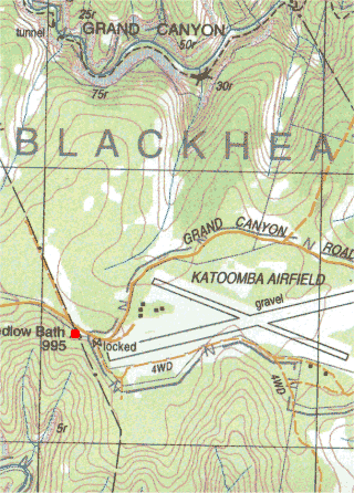 |
| 2nd edition (old series) Katoomba sheet (AMG) | 3rd edition (new series) Katoomba sheet (MGA) |
GPS
If you are using a GPS, switching between the two is fairly easy. The settings can usually be found in the GPS under Setup -> Units or something similar. First make sure the grid is set to UTM/UPS, rather than latitude/longitude. Then select the appropriate map datum.
- For old maps, select AGD66 (Aust Geod 66).
- For new maps, select WGS 84 (World Geodetic Survey 1984). GDA94 is essentially the same as WGS 84.